SUMMARY
This draft report is the result of discussions over the
past month by Kristen, Adam, and Hugh with recent research by Hugh.
Except where noted it is the conclusion of all. However, what is
concluded is tentative and needs review by other authorities. Above
all, Kristen, Adam, and Hugh recognize that in Florida only local
government officials can make community decisions about hurricane
evacuation. We offer it in the spirit of proactive community
engagement.
The main finding of this work is that El Portal
has an extremely serious and potentially life-threatening flood
possibility in a future hurricane. This would happen in a major
hurricane but could also happen if a lesser hurricane or tropical
storm results in an extreme rainfall event. Furthermore, El Portal is
also likely to have less serious but still problematic amounts of flooding
occurring on an almost annual basis (as was the case over this past
Memorial Day).
In terms of recommendations, El Portal and
its residents now have the information to know exactly which homes
would be at life-threatening risk in a major flood event. We strongly
advise the Village to work with County Emergency Management to
develop an evacuation plan based on this information and we will
support this effort in any way we can. Resident planning will require
particular attention this year in light of COVID-19 concerns and
potential difficulties in sheltering or evacuation scenarios during a
pandemic. We strongly urge residents in likely flood zones to have
advance plans in place in light of these concerns.
|
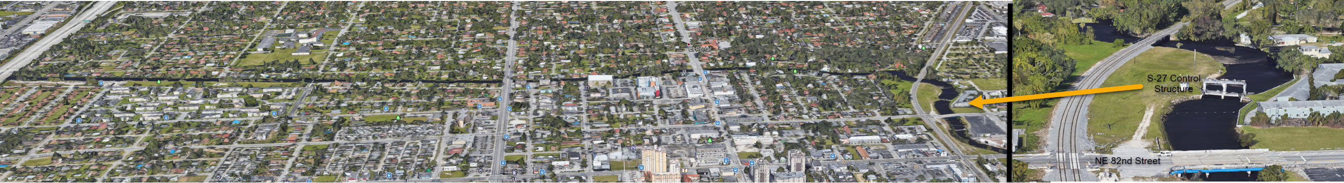
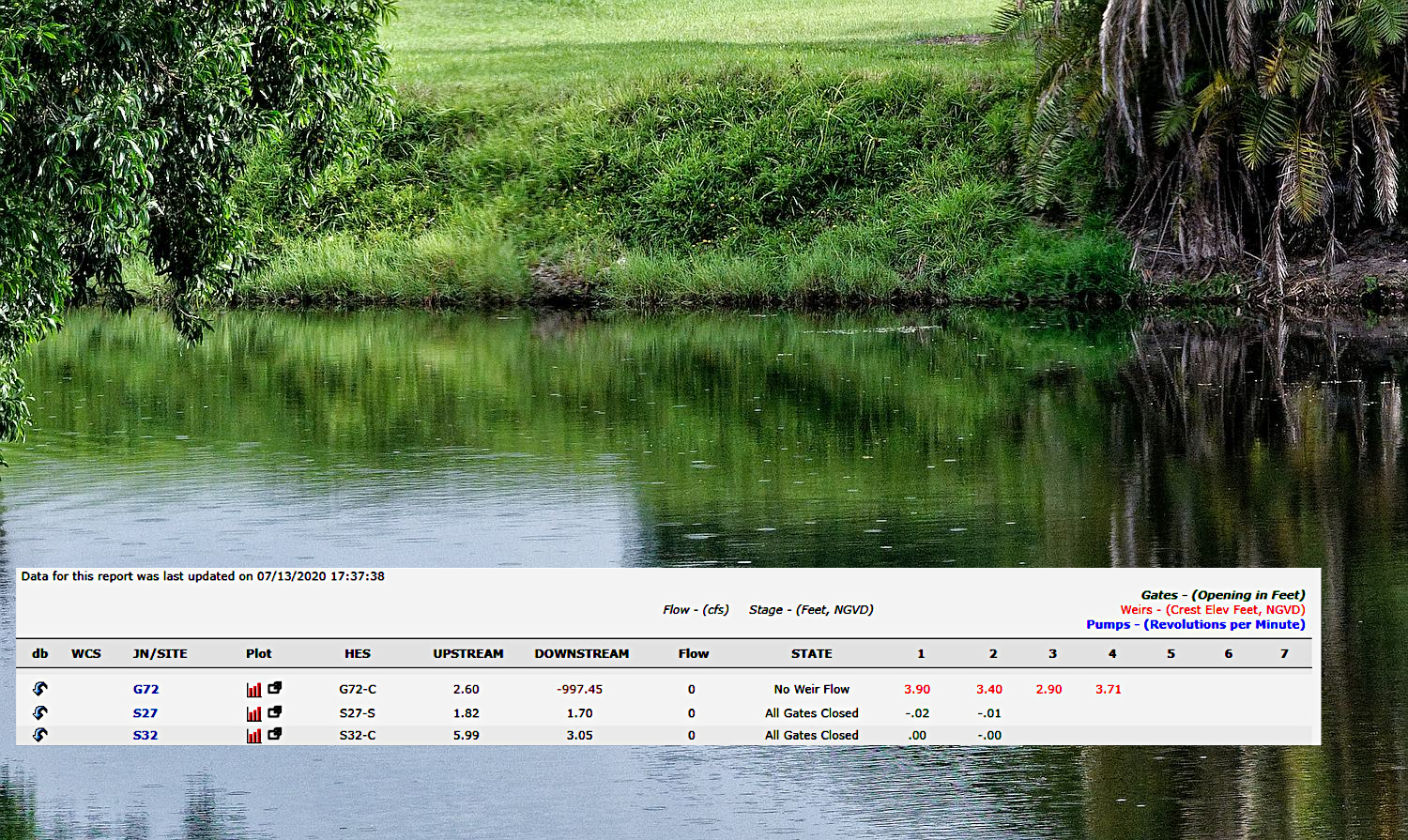
The water level in El Portal upstream of the S27 was 1.82
feet above sea level at the time the picture was taken. This
data can be found at
https://www.sfwmd.gov/science-data/current-water-conditions
(click on MIAMI). This link produces a huge chart of all the
structures operated by SFWMD. The most important ones for El
Portal are the S27, the S32 where water comes into NW
Miami-Dade from Lake Okeechobee and the Everglades, and the
G72 located where the C-7 canal begins west of Hialeah. 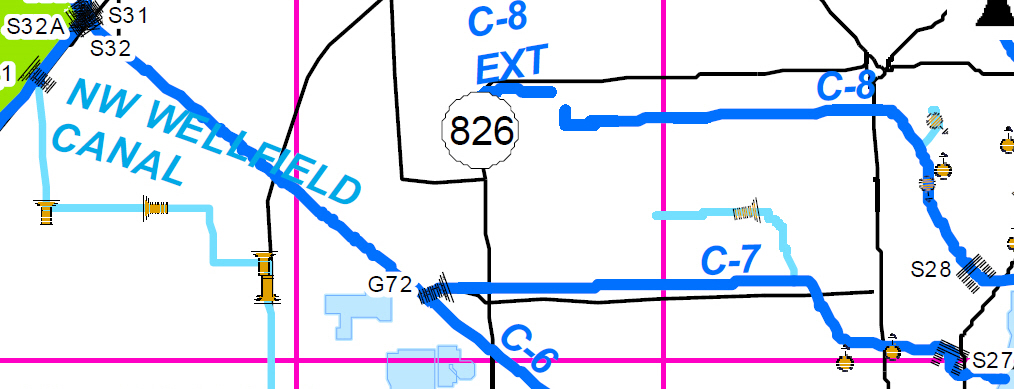
see low tide
comparison of picture at left
|
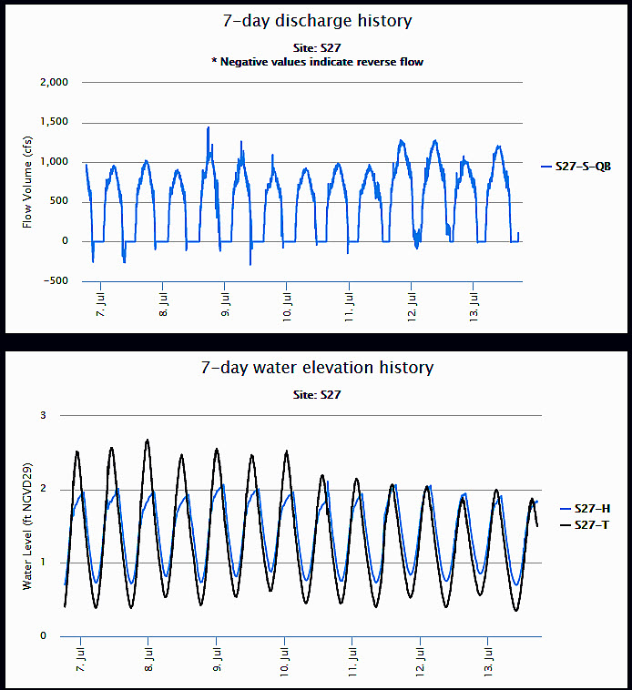
This chart shows the water flow and levels at the S27
structure for 7 days. The lower panel shows the headwater
upstream in El Portal in blue and downstream (tailwater =
tide level in Biscayne Bay) in black. You can see that the
Biscayne Bay water level has gone up to 2 1/2 ft but SFWMD
has kept water level in El Portal at maximum of two feet.
When the tide level in the Bay drops to 1/2 ft and the water
upstream is 2 feet water flows through the gates at over
1000 cubic feet per second (upper panel). There are no
pumps on the structure so if water above and below it are at
the same level there is no water flow. You can see that
there is occasional negative flow with water going upstream
briefly before the gates close--this may be because the
structure has sensors to keep that gates open while manatees
are swimming under.
Big problem: the river fills fast and drains slowlySuppose we have heavy rain and the canal water level in El Portal is at 3 ft, close to flood level in the lowest-lying areas of the Village. At low tide in Biscayne Bay the gates can drain water quickly but not fast enough to keep up with heavy rainfall in the Village and flowing down the canal from NW Miami-Dade. At high tide in the Bay there is almost no difference in water level upstream and downstream of the structure and almost no water flow. During the seven days covered in this chart there were daily thunderstorms but no flood level rainfall amounts and you can see the slow process of working the water level to keep it below 2 ft in the canal at high tide in the Bay.Unfortunately as shown below, just as the process of getting floodwater drained out of the canal is slow, the process of draining floodwater out of El Portal is also very slow. And the reverse is true in both cases, in heavy rain the canal can rise quickly as can flooding in El Portal.
If you want to see the current chart of the past seven
days go to https://apps.sfwmd.gov/sitestatus/ select EAST COAST tab at top right, then scroll down to Miami-Dade Canals C-7 Canal, then click  and wait for chart to be generated 
|
you can click on this and other images to see full size, then browser back button to return |
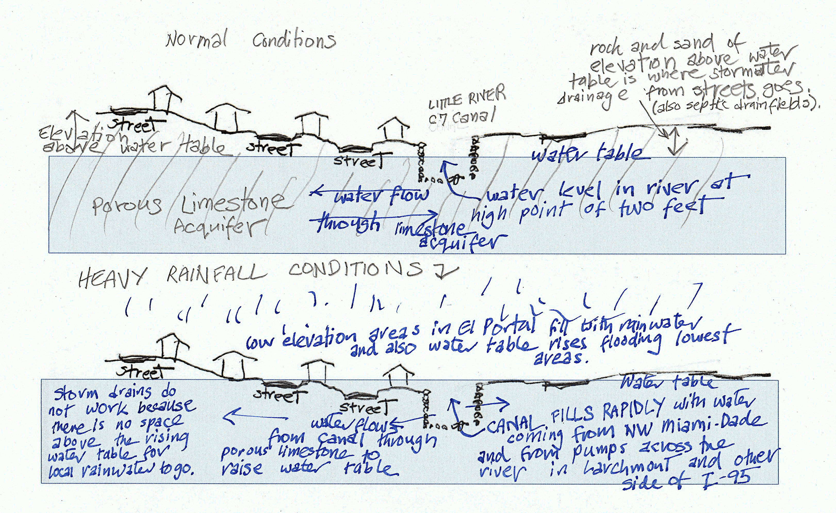
Every so often, we have an event where very heavy rainfall in El
Portal and upstream in areas draining into the Little River C7 canal
causes flooding in lower elevation areas of the Village. This
happened this past spring and it happens in heavy rainfall tropical
storm events like the No Name Storm and the first hurricane Irene (1999). With climate change bringing increased
rainfall we can expect these events to happen on average every year.
As shown above the canal cannot be drained during high tides in
Biscayne Bay. And if the rain is part of a tropical storm even a
small amount of storm surge in the Bay (even less than one foot)
constrains drainage even more.
In these events water levels in in the river and El Portal will
rise to 5 ft above sea level. In low-lying areas some streets are at 2
feet elevation with base elevations of houses around them usually a
foot or so higher. Homes with base elevations below 5 ft should be
given information on obtaining sandbags or other devices to keep water
out of their homes in these flood events. Our rough estimate is that
there are about 50 homes in El Portal at 3 ft elevation or lower and
an additional 75 in the 3 to 4 ft elevation range. As discussed above
it can take many days for flood water to drain from the river allowing
the water table to drop and and storm drains work better. Keeping
flood water out of these low elevation homes is essential to avoid
permanent damage.
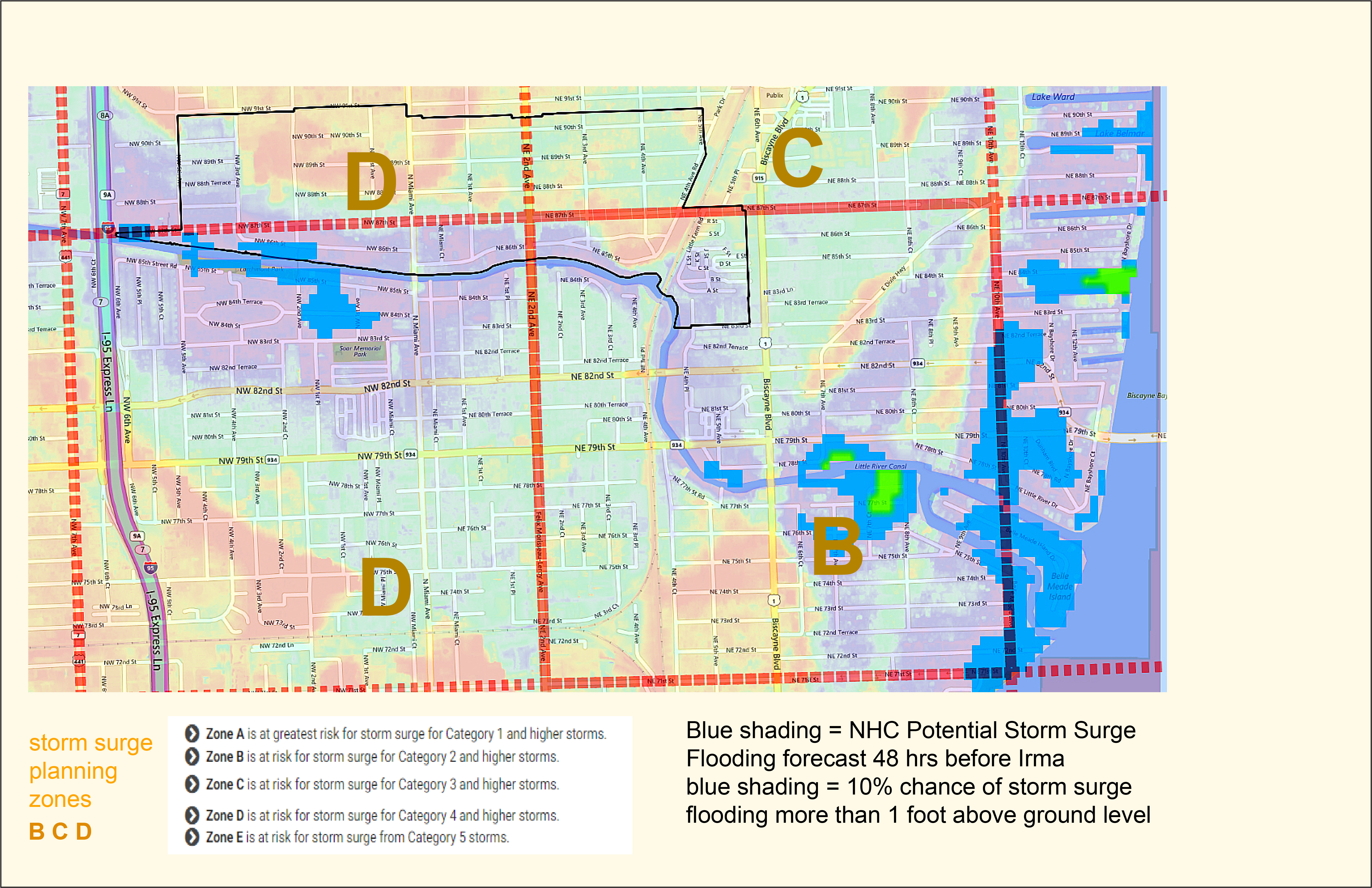
Wind damage and flooding are the major hazards of hurricanes. Risks of death and injury from wind will be discussed below under reasons for evacuation. Flooding from storm surge and rain is the major cause of death from hurricanes and is a obviously a major risk to many areas of El Portal for the reasons discussed above. Normal high tides in Biscayne Bay slow drainage through the S27 structure—add storm surge in Biscayne Bay and drainage through the structure gates becomes impossible. The heavy rain tropical storms and hurricanes usually bring adds to the problem. And of course if high Biscayne Bay storm surge flows into the river that itself floods and raises the water table.
This requires considering what storm surge is and does *. Storm surge is produced by water being pushed toward shore by the force of hurricane wind but many factors affect the height of storm surge in addition to wind speed. A hurricane covering a large area like Sandy can produce high storm surge even with only category 1 wind. The configuration of the ocean bottom is very important -- where it slopes up gradually as on Florida's west coast a surge of water 15-20 ft above ground is possible when it goes onshore. Offshore of Miami the water is deep and absolute worst case of a large area category 5 hurricane coming in at a perfect angle to push water into Biscayne Bay could raise Bay water to 9 ft above normal sea level (map). Even with the S27 gates closed this amount of surge would flow around it to flood the Village. However this eventuality is extremely unlikely. Far more likely is a similar amount of flooding from a slow moving less strong hurricane dumping huge amounts of rain like Harvey in Texas 1917. Every hurricane season this is a distinct possibility and we have to consider what level of flooding could occur in different areas of El Portal.
If this kind of rain looks possible and storm surge is not predicted to be higher than a few feet SFWMD will probably do as they did in Irma. The S27 gates are locked open and surging salt water from Biscayne Bay pushes upstream the river flooding low areas. When water level in the Bay goes down flood water can flow back through the open gates. In such a case if we do not have heavy rain the maximum flood level is the surge level. In Irma this was about 5 ft resulting in 3 ft of flood water above ground in the most low lying areas. There was less rain than expected in Irma so that was as high as it got.
Unfortunately we can never count on a hurricane having little rain so it is important to plan for the amount of flooding heavy rain could bring. This keeping in mind that even with the S-27 gates open, storm surge will be blocking the river to cause large amounts of water to pile up. If the water in the river is higher than 6 feet it will start to flow around the S-27. However that does not set a maximum because hurricane debris ( example) flowing down the river could block the FEC railroad bridge which is 9 feet high.
Given these factors, we feel it is prudent to plan for possible
flood waters in a major hurricane to be up to 7 feet above sea level
with a less likely possibility of going to 8 feet. It is generally
felt that people sheltering in their homes will be safe if they know
water in their home will go no higher than two feet above the floor.
More than that, they should evacuate. This sets a home base elevation
of 5 feet or lower as a requirement for evacuation. It does leave
some in homes possibly getting flooded but not to a life-threatening extent.
The map below shows the boundary of 5 foot approximate elevation in
red (color shading and numbers show elevation in feet).
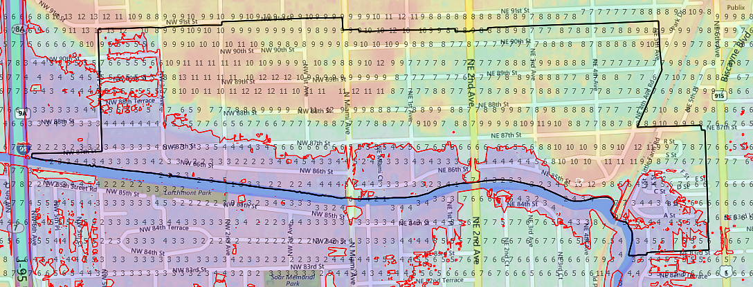
Unfortunately proposing to require evacuation in the area marked in
the map above creates a problem that would have to be resolved with
County Emergency Management.
At this point we shift gears and let Hugh do the speaking since what might be the best approach will be controversial.
Wind damage resulting in death of occupants. For regular houses built to code in Miami area this risk is minimal. In Hurricane Andrew over 60,000 homes were considered destroyed though most had people in them during the storm. In them there were only a handful of deaths directly caused by wind effects. Andrew wind was cat 5 ground level in south Dade (=F2 tornado) but almost all major hurricanes have actual ground wind less when they reach an urban area. Since the closing of the trailer park almost all houses in El Portal should be safe refuges from wind if they have window and door protection. No one wants to go through the experience of sheltering in the strongest part of a house in the noise and wind shaking of a major hurricane but the chance of surviving will be better there than a risky last-minute evacuation out of the area.
Drowning. This is the main cause of
death from hurricanes. As discussed above we know there are homes in the
Village at risk for this and occupants of them should have an
evacuation plan ready to put into effect 48 hours or more before
expected hurricane landfall if advised to evacuate. The
timing of that is discussed below.
What is most important to emphasize about risk from flood
water in El Portal is that is more likely to be from flood water
backing up in a major rainfall event than from storm surge only.
This means a slow moving category 1 or 2 hurricane could produce
life-threatening flooding in El Portal even if not much storm surge
is forecast.
Death or injury resulting from events during evacuation. This is minimal for evacuation to homes of friends or family in the local area providing Covid 19 risks are minimized. Evacuation by car out of the area always has had risks in south Florida due to limited road capacity resulting in traffic gridlock. In Irma we were very lucky it followed the forecast track shifted west at the last minute and did not expose cars stranded on highways to extreme winds. And with the pandemic last minute panic evacuation is extremely risky.
Need medical devices for life support that would not work in power outage or other major health problems. Should register with Miami-Dade Emergency & Evacuation Assistance 305-513-7700.
Not wanting to be in the area for the horribleness of it all including the aftermath. Understandable, but evacuate early even if it winds up being a false alarm.
At this point in the hurricane season (July 17) everyone living in El Portal should have their hurricane plan ready. This means all the usual things: having window and door protection ready to install if needed, non-perishable food and other supplies ready for at least ten days without power and access to stores, cash and fuel supplies topped off, etc. Homes with low base elevation should have a way to seal door openings from water coming in.
Most all, as discussed above, everyone has to decide now whether or not they will need to evacuate for a major hurricane. In some cases it may because their house is not strong enough to withstand hurricane force winds but in most cases it will be due to flood risk for low elevation homes. If they will need to evacuate they need to have a plan now for where they will go, what it will take to get there, and have quickly packable what they will need to bring. The best option is to go to the home of a friend, family member, or neighbor living in a safe location, the nearer the better given the difficulty of traveling these days. This has to agreed upon with them now keeping in mind we all have to do what is necessary protect each other from infection. People with no other option should go to a county shelter. There will be enough available and they will all have Covid 19 prevention measures in places. There will also be shelters for people with pets.
When to evacuate: if people are prepared and know what they are going to do they should simply evacuate when there is enough time to get safely where they are going to go. In El Portal people will not need to wait for an evacuation order because they will know what to do. People at major flood risk in the Village will have to evacuate for a major hurricane or a lesser one if it is predicted to bring heavy rainfall.
An advantage of planning to evacuate locally is that one is less likely to evacuate and then find out the hurricane went elsewhere. 48 hours before the predicted arrival time of a hurricane we will have a good idea of how bad it will be here and that leaves enough time to get to a destination in Miami-Dade or Broward. For a destination elsewhere in Florida or out of state 48 hours ahead has always been too late and this year is out of the question. Travel is so difficult these days that the travel has to be planned now so it can realistically accomplished a number of days before expected hurricane landfall.
| These flooding events prompted Miami-Dade County to
start a major effort. The C-4 Tamiami Canal was selected for the
first project. $18 million of FEMA mitigation funding was allocated
by the Miami-Dade Local Mitigation Strategy (LMS) after the 2004/2005
hurricanes. New pumps were put in and a detention basin was built to
hold flood water to be released slowly without flooding downstream.
Result is that Sweetwater no longer floods. The C-7 canal basin was supposed to be next since it drains such a large area of Miami-Dade County. Funding has never been obtained to start that project although planning is going on for it (see below). In the meantime, instead of a detention basin to hold back flood water, new development is going forward paving areas where flood water was formerly absorbed to now increase runoff into the canal system. |
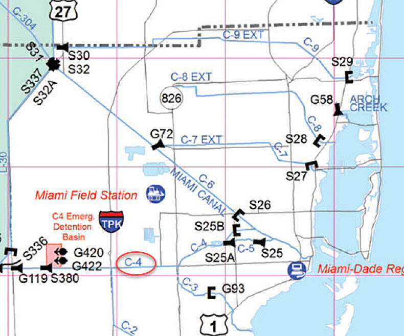 |
Flood Protection Level of Service Assessment for C7 BasinThis is an planning project run by the Miami-Dade County Office of Resilience and SFWD over the past few years in collaboration with other County agencies and municipalities in the area. El Portal has been a very active participant in the workshops of this process. One of the first workshops showed alarming effects of sea level rise when modeling was done to see how much worse flooding will be when drainage from gravity flow through the canal system and the S-27 structure would be reduced. This image shows what would happen to El Portal and if you click on the image you will see that El Portal, at the drain end of the C-7, will have the most severe effects in the area. What is needed: pumpsThere needs to be a large pump on the S-27 structure to drain the C-7 canal when water levels in Biscayne Bay are higher. There also needs to be pumps on in the El Portal area to remove flood water and lower the water table. As you can see in the SFWMD map below there are pumps on the other side of the canal in Larchmont and on the other side of I-95. Those pumps are needed but in recent flood events we have seen that the water they pump further raises the canal water level increasing flooding in El Portal.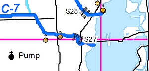 El Portal has two proposals for needed pumps moving up up through the Local Mitigation Strategy (LMS) Local Mitigation Strategy (LMS) priority process. We hope these will be funded the next time a large amount of FEMA mitigation funding comes to the County.
|
model results and report 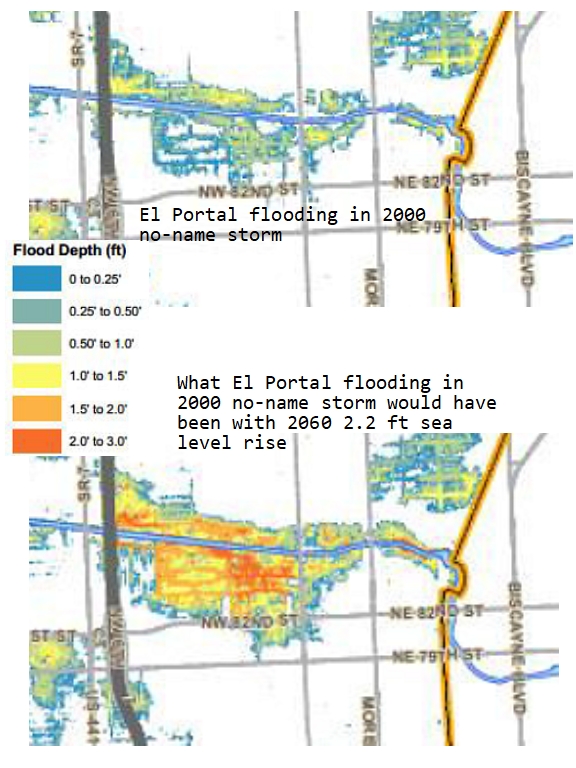 |
